LibreWaterNet

A community-owned project, built in the open

World
owned.

Water network design and management software for everybody everywhere.

Looking for stakeholders, not for money. We are building this together, and the people who use it should own it. Come and tell us what you need it to be.

Free, no sign-up, runs in your browser · Open an example · See it working

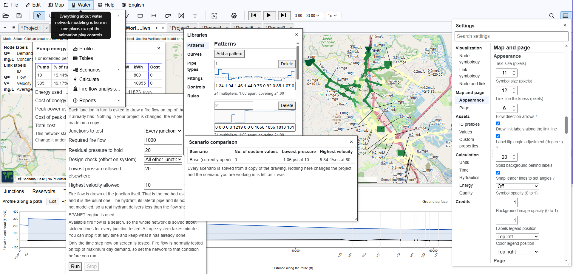
One browser window showing a water network on a street map with the Settings box, the Libraries box, a fire flow analysis, a pump energy report, a scenario comparison and a hydraulic profile all open over it.
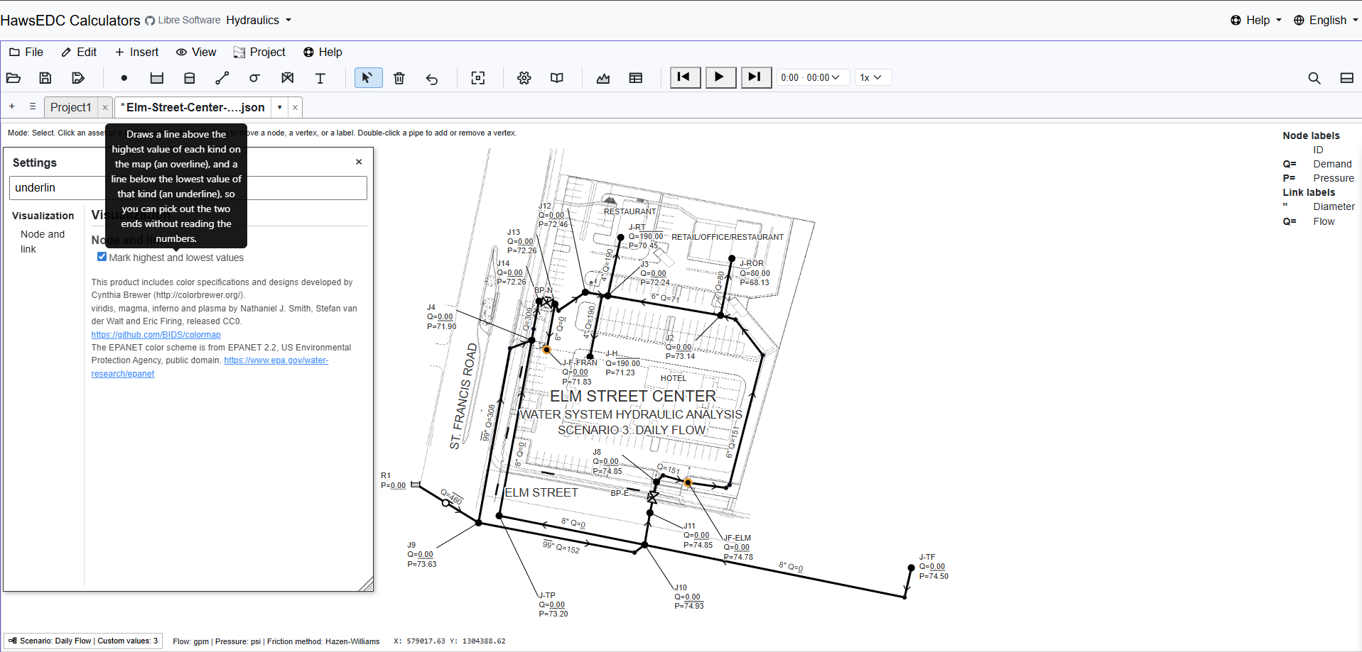
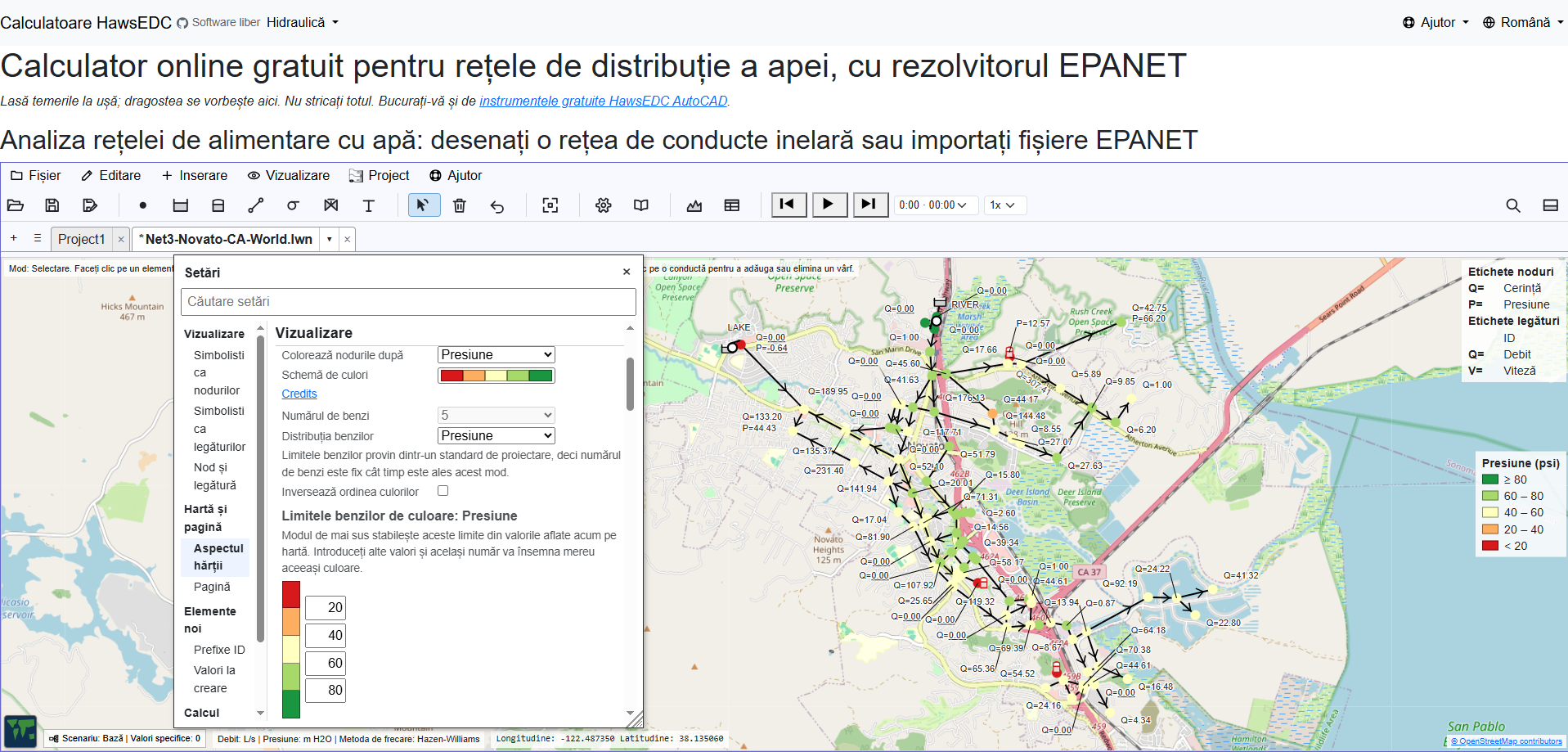
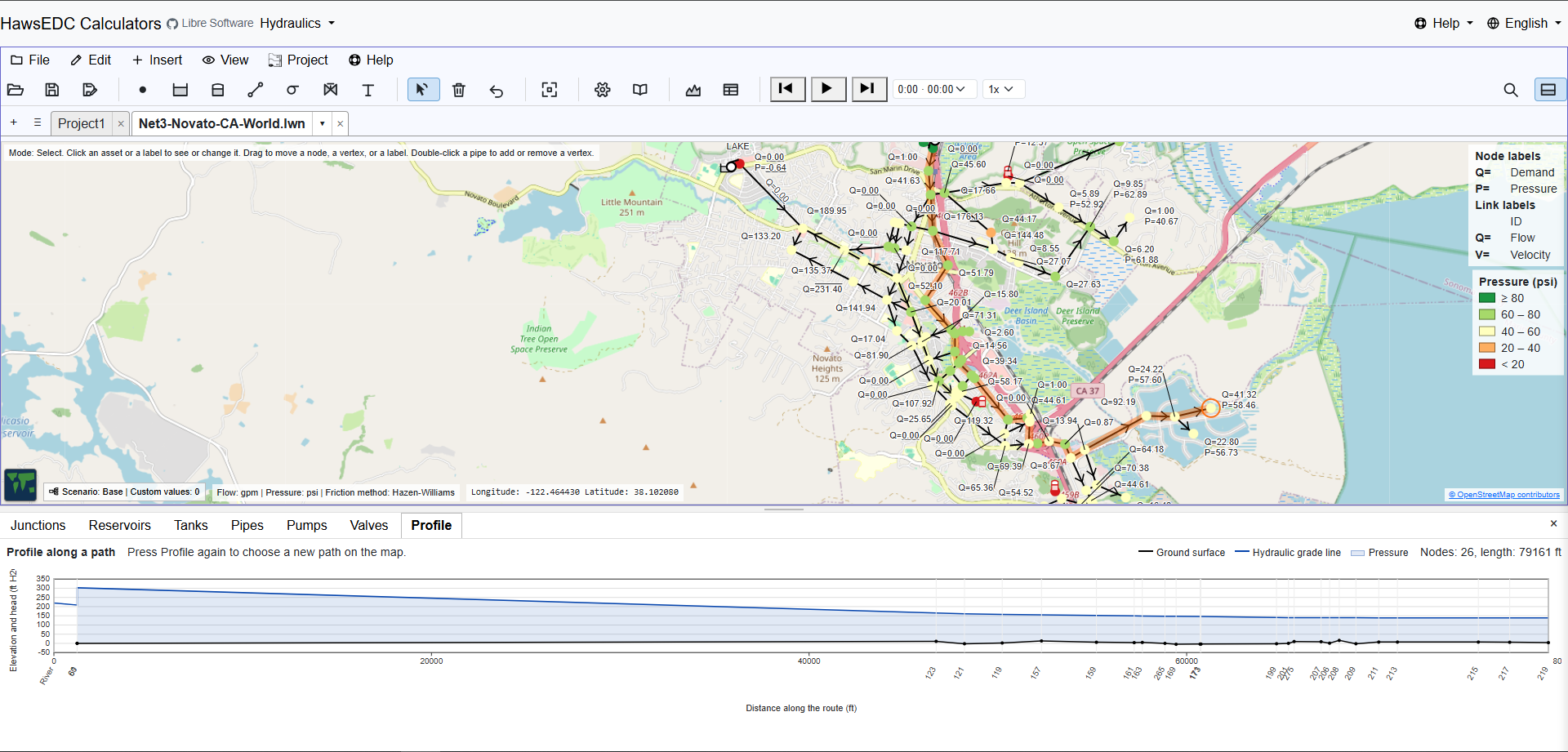
A water network on a street map of Novato, California, colored by pressure, with a hydraulic profile along a chosen path in the pane beneath it. A water network drawn over a site plan with hand-placed labels, leader lines and a title block. The same software with its entire interface in Romanian.
Settings, Libraries, fire flow, pump energy, scenarios, tables and a profile, all open on one network · EPA’s Net3 on real streets · a design drawing on a site plan · the interface in Romanian · twelve more, annotated
Network
EPA Net3
Junctions
92
Engine
EPANET
License
GPL v3+
Looking for stakeholders, not for money

Four kinds of person we are looking for

There is no intention to offer anything to buy here or add a donation button, and everything you see is yours and ours together. We are asking for your time, your judgement, your experience, the bug you hit, and the thing you need it to do next. What the project is short of is people who will steer it; and it is early enough that steering still changes where it goes.

Advisors

How should a piece of software be owned by the people who depend on it? We do not know yet. We have directors-in-waiting, and founder Tom Haws, P.E. is an experienced nonprofit CEO, but we have chosen to wait for clarity before forming a foundation or writing a governing document; that is why we are asking before writing one.

Bug reports

The most useful thing anyone sends us is a network that behaves in a way you did not expect. Send the model and what you expected; that is a complete report.

Power users with wish lists

People who model networks all day know what is missing better than we do. Tell us what you need it to do, in the order you need it. Your wish list is our specification.

Non-profit directors

Water systems get designed and run by organizations without a software budget. If that is you, we want to hear what stands between your engineers and a model they can actually use.

If the answer to a question is “we have not decided that yet,” we would rather say so and hear from you than publish a plan nobody outside the project has read.

What exists today

It is not a proposal. It runs, the screenshots are real, and it’s waiting for your feature request.

If you came here wanting a water network model rather than a project to join: it is built, it is free, and you can open it right now. It solves, it draws, and it creates report-quality annotation.

Draw

Junctions, reservoirs, tanks, pipes, pumps, valves, and annotation text, placed on your XY system or on a Lat/Lon map (WGS 84 / Pseudo-Mercator EPSG:3857) with street or satellite view. Open an EPANET .inp file and it tells you every difference it found rather than ignoring anything quietly. It also opens the .net file EPANET saves, which we decoded by working the format out from examples, and the page tells you to trust that route less. Write an .inp back out and every number you did not change comes back character for character.

Solve

Pressures and flows internally from the global gradient method, or from the EPANET engine itself running in your browser. Solve one moment, or run an extended period, with demand patterns, simple controls, tanks that fill and drain, with animation play and step controls. For an extended period simulation, the EPANET engine also answers water quality questions: how old the water reaching a point is, how much of it came from a source you name, and how a chemical residual decays on the way. The same run says how long each pump ran, the power it drew, the energy it used and what that cost. Color the map by pressure, flow, velocity or head loss, in any of 41 color ramps.

Label

Labels you control. Drag one where you want it, set what it says, and it stays there, with leader lines that follow. What leaves the screen is a screen capture; what the lettering saves you is the redrawing of the map by hand in a drawing program.

The edges: we know what we built and we know some of what we lack, and we do not know the size of the gap between this and the software an experienced modeller is used to. What we do know: a run over time goes through the EPANET engine, and the built-in solver has no time dimension. Active valves, the kind that set their own position, solve through that engine too. And although you of course prefer working on your PC, it works also on a phone in tall mode.

27 languages

Everybody everywhere is the aim

English Español Português Français Türkçe Deutsch Italiano Русский Українська 中文 हिन्दी বাংলা العربية فارسی עברית اردو پښتو Bahasa Indonesia Kiswahili አማርኛ ភាសាខ្មែរ မြန်မာ Български Čeština Hrvatski Română Srpski

Twenty-seven languages is not every language, and the list here is how far the aim has got, not the end of it. What is translated is translated in the program itself, the labels, the tooltips and the warnings, rather than left for your browser to paper over an English program, unlike this welcome page, which is in English, and which your browser has translated if you are reading it in another one. Every word is evaluated for translation: where a word is still in English, that is a decision on the record and not something that slipped past us. The network model and the two Manning calculators go into all twenty-seven languages; the rest of the suite into Spanish, Portuguese, French, and Turkish, and every calculator is findable by name in every language while it waits its turn.

The translations are AI-made, term by term against a hydraulics glossary, and corrected as people report what reads wrong. The quality of each language is recorded openly, and the ones with the fewest speakers to check them are the ones we are least sure of. Your feedback improves every language, English included. Right-to-left languages lay out right-to-left.

Nothing else in the project has taken as much work, and it exists because the people who most need a free network solver are very often not working in English. If your language is here and reads badly, that is a bug report we want.
Why

The people who need it most cannot buy it

A water system serving ten thousand people has the same physics as one serving a million, and the engineer in front of it deserves the same tools. Software budgets are not handed out the way water problems are. That is the reason it is free; the license below is what makes that permanent.

So this is a mission and not a product, which is also why we are asking for stakeholders instead of customers. A product needs buyers. What this needs is people who will say what it has to be, and then hold us to it.

License

World owned means yours to keep

LibreWaterNet is GNU GPL v3 or later. There is no paid tier, no free tier that can be taken away later, and no waiting period before the source is yours. Fork it, run it on your own server, teach from it, ship it inside something else that is also free.

What is published under that license stays published: this code cannot be made proprietary later, by anyone, including us. Nobody can promise what comes next, only that what you already have stays yours.

Your model stays on your machine. Every calculation runs in your own browser; nothing you draw is uploaded unless you turn on a feature that needs it. There is no account to make. Install it and it keeps working with the network cable out.

Four features reach another server. The street map shows on the first, empty project, and Map, World map, Detach hides it. The other three are off until you turn them on:

  • Street map tiles, from OpenStreetMap.
  • Satellite tiles, from Mapbox.
  • Place-name search, which sends what you typed to OpenStreetMap’s geocoder.
  • Ground elevations, which send the coordinates of your nodes to Mapbox.

The last two ask a consent question of their own.